

Drone workshop for educators takes flight at Virginia Tech
Educators from across Virginia took their experience with unmanned aircraft systems (UAS), also known as drones, to new heights during the second year of a summer program offered on Virginia Tech’s Blacksburg campus.
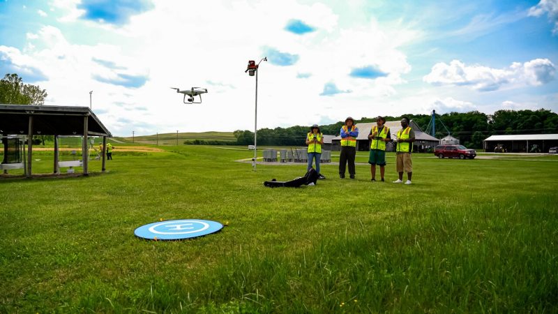
The program led by John McGee, a geospatial Virginia Cooperative Extension specialist at Virginia Tech, gave the group hands-on lessons with the drones. Everything they learned they will take back to their students and integrate into their own curriculum.
The Improving Pathways into the Geospatial and Unmanned Aircraft Systems Technician Workforce 2023 Faculty UAS Institute (GeoTEd-UAS) was hosted by Virginia Tech this May. The GeoTEd-UAS project team includes the Virginia Space Grant Consortium, Germanna Community College, Virginia Tech, Virginia Cooperative Extension, and the Virginia Community College System.
“Our mission is to train educators, including community college faculty, high school teachers, and Extension agents on how to integrate drones into instruction. We are teaching them how to prepare the future drone workforce,” said Chris Carter, the director of the Virginia Space Grant Consortium. “Funding from the National Science Foundation has supported the development of new UAS classes at the community college and high school levels. Funding has also supported the professional development and hands-on training of educators.”
The uses for geospatial technologies and small unmanned aircraft systems are rapidly increasing and creating a demand for skilled technicians to support the growing industry. Drones and their ability to collect and analyze high resolution geospatial data on demand are poised to transform businesses, impact safety and security, improve health, and reshape the economy.
“Drones represent a transformative and cornerstone technology for many different industries, including agriculture, natural resource management including forestry, watershed management, wildlife management; engineering, inspection services, and public safety. Naturally, we are seeing a huge employment demand for a skilled workforce. This demand, which will support Virginia’s future economy is the basis for the GeoTEd-UAS project and for the training and educational efforts,” McGee said.
This was the second year of the workshop. Last summer, participants earned their Part 107 remote pilot certificate from the Federal Aviation Administration and learned about the regulatory environment necessary for safe and legal drone operations and educational programs. That included topics such as flight planning, flight operational strategies, safety, project management, flight operations, data collection, and image processing.
This year's focus was to reinforce those skills and delve into new topics, such as autonomous data collection using drones and sensors, best practices for collecting data, how to process and analyze data, as well as image processing, McGee said.
“This has been amazing. The level of training that we've received has given me a lot of practice and gives me projects to take back to my students,” said Trevor Brickman, a teacher at Surry County High School. “Plus, it's a diverse group. We’ve got a geology professor, geography teacher, someone who's in law enforcement, whereas I'm looking at it from a drone educator's point of view. We all bring different perspectives. I'm learning from them, but I'm also sharing with them.”
Participants are from all over Virginia and have different needs.
Judy Gill, a professor at Tidewater Community College, focuses on certifying students seeking their Part 107 remote pilot certificates. Because of the nearby Naval Air Station Oceana, home to F/A-18 Super Hornets, Gill teachers her students about waivers and different rules when flying so close to a U.S. naval base.
“It's a very different type of flying by us. We are more likely to use drones in our area for things like inspections or delivery or things like that. DroneUp, a large drone company, is right in our area,” Gill said.
Bryon Pierce, an agriculture educator at Surry County High School and sixth generation farmer, is trying to reshape his students’ attitudes about agriculture.
“When people think about agriculture, they don’t often think of technology. However, it's 2023. There are a lot of agricultural issues — food deserts, food scarcity. Not only that, but people also don’t recognize that there is a lack of farmers today. So incorporating drones into my curriculum will hopefully entice more students to learn more about farming and spark interest in how to incorporate them into their farming practices,” Pierce said.
UAS are still new and many students are unaware of the career opportunities that are available. One of the main goals of GeoTEd-UAS is to create interest in this new field, particularly among students in underrepresented groups. Because many of these programs and classes have not been around very long, teachers must get creative in appealing to their students.
“For us, we're building the program. It's only the second year that we're doing it. I show up at field day and other events and fly around so the middle schoolers see us using the drones, and it’s those kinds of things that stimulate the interest. You have to start somewhere, and people don't really realize what they're useful for,” Brickman said.
Written by Caroline Reed, a senior and an intern for Virginia Tech Communications and Marketing


